When you apply, you must give details of
- the flight volume and contingency volume that make up your operational volume, including how you determined their size
- your ground risk buffer, including how you determined its size
Use the 'operational volume and ground risk buffer' section during Assessment 1 for this.
Give the information set out below.
Flight volume and contingency volume
Give the following details:
- latitude and longitude, as either a centre point with radius or multi-point polygon, in KML/KMZ format
- vertical extent in height above ground or altitude above sea level
Ground risk buffer
Give details of how you calculated your ground risk buffer. Your calculation must reflect the flight characteristics of your unmanned aircraft and the containment requirements.
There's more information on calculating your ground risk buffer in JARUS guidelines on SORA, Annex A, Guidelines on collecting and presenting system and operation information for a specific UAS operation (opens in a new tab).
Technical details of your unmanned aircraft
Give any technical details of your unmanned aircraft that we'll need to validate your proposed contingency volume and ground risk buffer.
The following are just some examples of the type of technical detail that may be necessary. You should also provide any further information that may be relevant.
Examples for fixed-wing aircraft
- Turn radius of your fixed-wing aircraft, which may partly determine your contingency volume
- Glide ratio of your fixed-wing aircraft, which may partly determine the size of your proposed ground risk buffer
Examples for multi-rotor aircraft
- Ballistic descent calculations
There's more information in JARUS guidelines on SORA, Annex F, Theoretical Basis for Ground Risk Classification and Mitigation (opens in a new tab).
Adjacent area
We'll calculate your adjacent area based on the maximum capable speed of your unmanned aircraft.
You can also work out your adjacent area using the calculation in the UK SORA policy.
Working out your adjacent area > (opens in a new tab)
Location procedures
Give details of any specific procedures you'll follow at a location, such as:
- maximum height of your operations
- maximum distance from remote pilot and/or visual observers
- take-off and landing locations
- any no-fly areas
Multiple locations
If you want an authorisation that covers multiple locations, read our information on using UK SORA with multiple locations.
Atypical Airspace Environment (AAE)
If you wish to claim you'll operate in an Atypical Airspace Environment (AAE) as part of a BVLOS operation, you must provide sufficient detail to support your claim.
Details of our AAE policy are in Unmanned Aircraft Operations in an Atypical Air Environment: Policy Concept, CAP 3040 (opens in a new tab)
AAEs and multiple locations
Although there's no legal limit on the number of operational volumes per operational authorisation, it's likely that separate procedures and safety arguments will be required for each AAE.
This means we recommend operators do not propose more than one AAE per application.
Contact us for more information: uksora@caa.co.uk
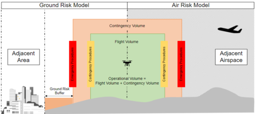
Working out your operational volume, ground risk buffer and adjacent area
The operational volume is made up of:
- the flight volume: the area where you plan to operate
- the contingency volume: an area around the flight volume, where you must perform contingency procedures if you enter
The ground risk buffer is the ground area where your unmanned aircraft should end its flight if it exits the contingency volume in a loss of control.
The adjacent area is the ground area where your unmanned aircraft would be reasonably expected to crash in the event of a loss of control situation.
Working out your operational volume and related areas > (opens in a new tab)